Built an AI tool that turns satellite imagery into optimised infrastructure rollout routes for rural electricity grid deployments
A computer vision and AI pipeline that processes satellite imagery to detect housing units and structures across remote terrain, generating efficient distribution routes for an electricity grid operator delivering connectivity to rural communities at scale.

Key Takeaways
A rural infrastructure deployment operator working on electricity grid expansion came to Unico Connect to replace the manual satellite image analysis that was constraining the pace of their rollouts. We built an AI tool that processes satellite imagery, detects housing and commercial structures automatically and generates optimised distribution routes for the grid expansion teams.
The tool cuts manual planning time substantially, improves accuracy in remote areas where ground surveys are impractical, and reduces the cost of getting infrastructure to the rural communities the operator serves.

The Challenge
Rural electricity grid expansion is structurally hard. The economics that make urban deployment straightforward (high density of customers, well-mapped terrain, established routes) break down in low-density rural areas. The operator has to identify where the customers actually are, plan distribution routes that reach them efficiently, and execute with crews and material that travel long distances to get there. Every step that depends on manual work scales linearly with the area covered, so at the scale of rural electrification the manual work becomes the bottleneck on deployment speed.
Before this engagement, the workflow for identifying housing units and structures was largely manual. Operators reviewed satellite imagery by hand, identified the structures that needed connectivity, plotted them on maps and then designed the distribution routes. A single deployment area could absorb days of operator time, and the maps were only as good as the operator attention to detail. Houses got missed, commercial structures got categorised wrong, and routes got designed against incomplete information, which meant re-work in the field.
The opportunity was clear. Satellite imagery is dense, detailed and consistent. Computer vision models can detect structures at accuracy levels comparable to manual review, in seconds rather than days. Combined with routing optimisation that maps detected structures into efficient distribution paths, the entire planning step could shift from days of manual work to a near-instant pipeline, producing faster deployments, lower planning costs and route designs that reflect what is actually on the ground.
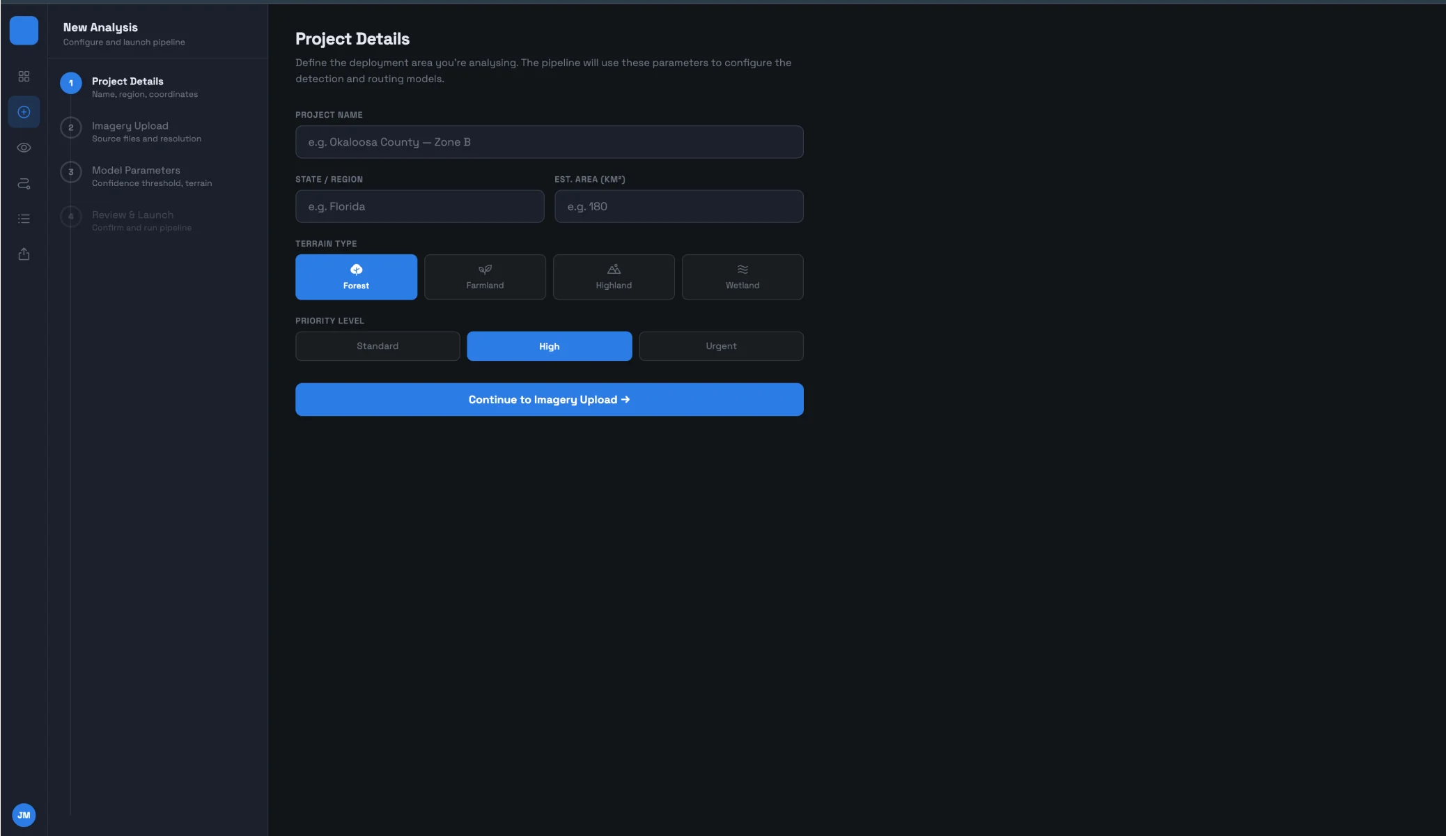
The accuracy threshold was non-negotiable, because customers missed at the planning stage often stay missed. The pipeline had to handle the formats and resolutions satellite imagery actually arrives in, the routing had to incorporate terrain constraints, existing infrastructure intersections and the regulatory considerations that affect where lines can run, and the tool had to be usable by the planning team rather than by data scientists.
Our Approach

We engaged as an AI capability partner, with the work structured around three integrated workstreams: the computer vision pipeline that detects structures from imagery, the routing optimisation layer that converts structure locations into deployment routes, and the application layer the planning team uses to drive both.
Key decisions:
Detection tuned to the imagery, not generic
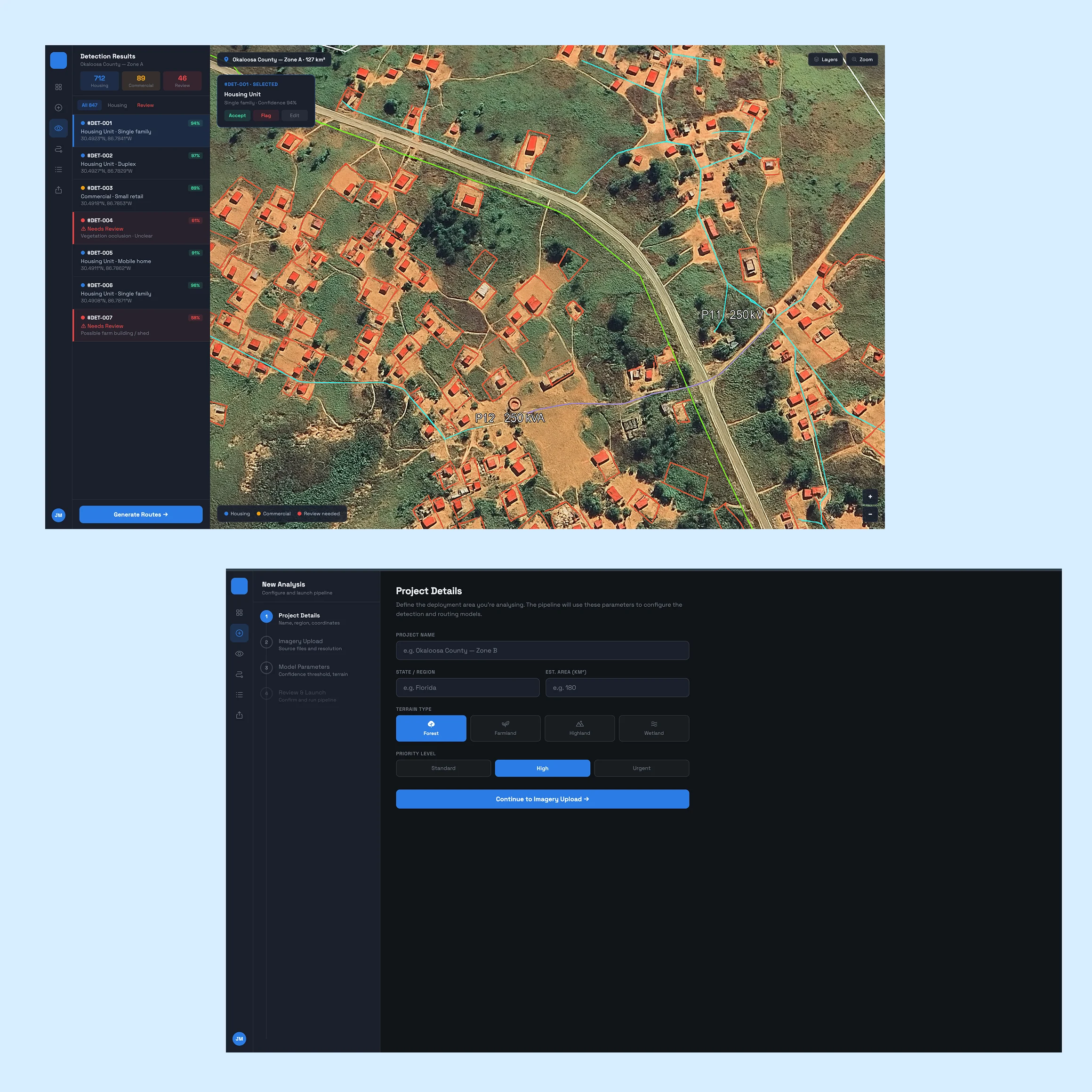
Built in Python with YOLO and OpenCV plus model components tuned to the engagement, the detection differentiates housing units from commercial structures from other structures (sheds, farm buildings, vehicles) because the routing treats them differently. We worked through the failure modes (cloud cover, unusual terrain, vegetation occlusion) and the fallback behaviour when the model is uncertain.
Routing that reflects the ground
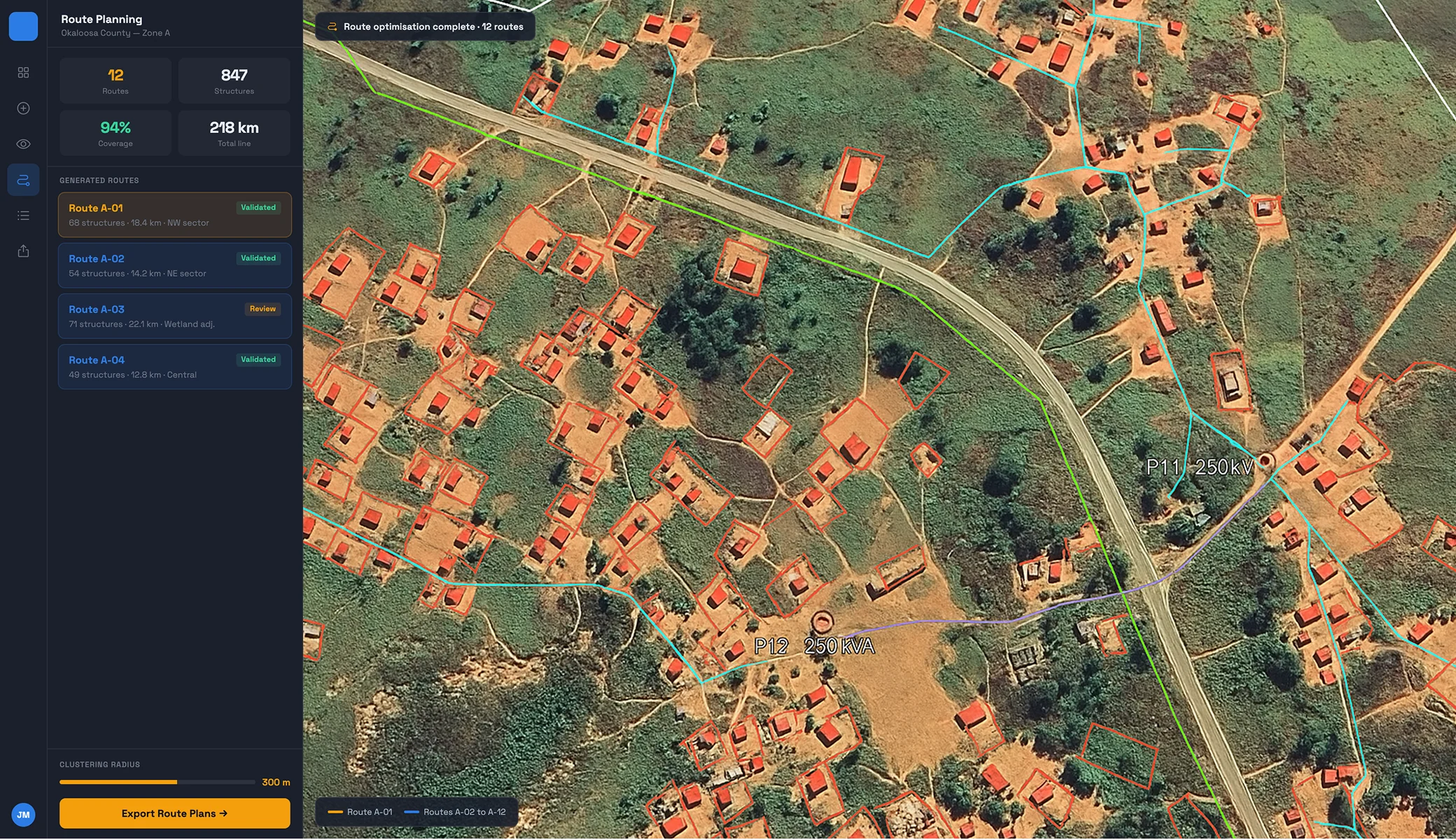
The optimisation clusters related structures into efficient sub-routes, avoids routes that are not practical for deployment crews, and incorporates the operational requirements specific to electricity grid distribution, producing a route plan the team can review, adjust and hand off.
Validated against ground truth, human in the loop
We worked closely with the operator operations team and tuned the pipeline against real deployment areas with known ground truth, which is what produced the accuracy improvements over the manual baseline. Uncertain detections are flagged for human review rather than guessed, and operators can adjust routes on edge cases.
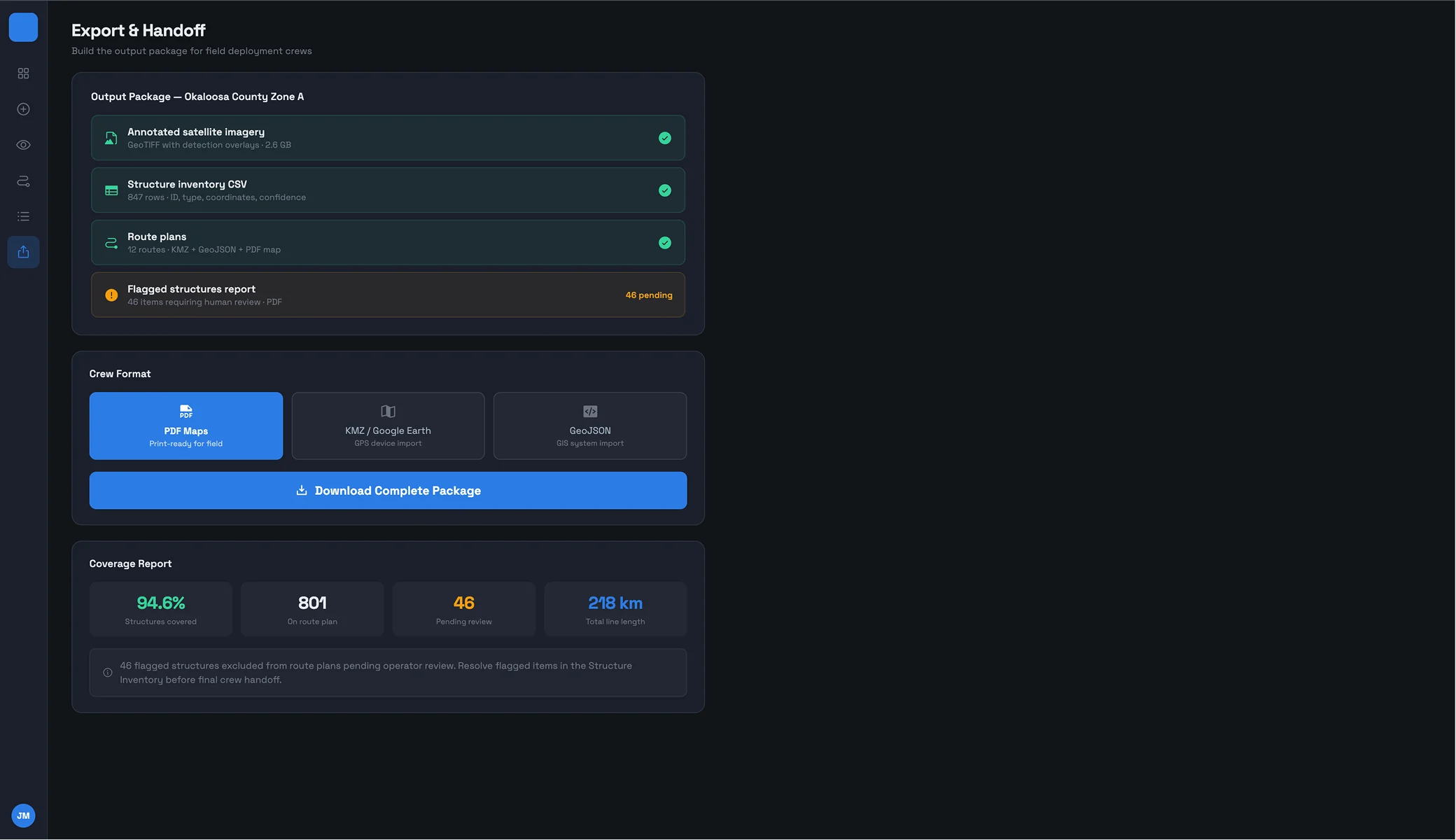
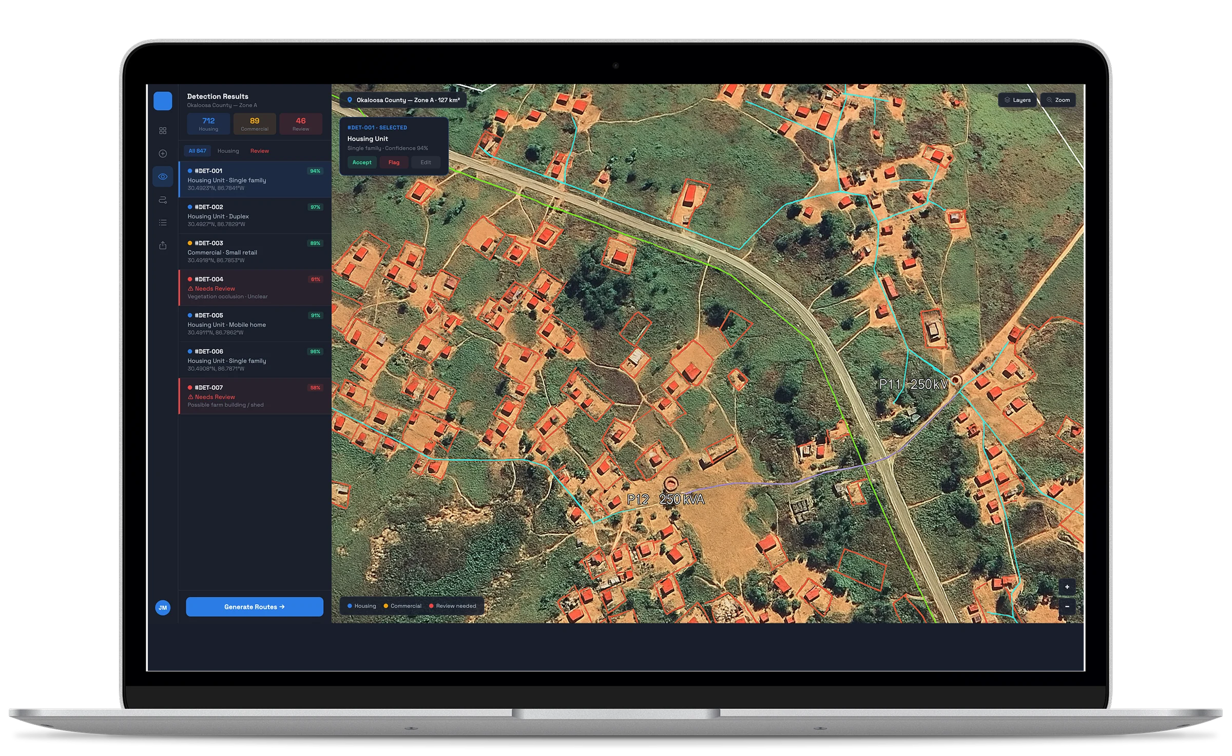
The solution we built
A complete pipeline that ingests satellite imagery, runs the computer vision detection, generates routing recommendations and presents the output to the planning team for review and finalisation.
Satellite imagery ingestion
Handles the satellite sources the operator uses. New deployment areas are processed by selecting the relevant imagery and running it through the pipeline, which absorbs the variation in source formats and resolutions that real-world imagery brings.
Computer vision detection
Python with YOLO for object detection and OpenCV for image processing identifies housing units, commercial structures and other features, with location data, classification and confidence scores for every detection.
Routing optimisation
Converts detected structures into deployment routes considering structure clustering, terrain practicality and grid-distribution constraints. The logic is configurable so the operator can adjust for urgency, terrain difficulty and regulatory considerations.
Operator review application
Shows the imagery, overlays detected structures with their classifications and confidence scores, and visualises the proposed routes. Operators accept confident output and adjust where they apply judgment, with every adjustment captured in the system.
Output handoff
Produces route plans in the formats the deployment crews actually use, maps, route descriptions and structure inventories, in a form the field teams can act on without additional preparation.
Tech stack


Outcomes & Impact
Planning speed
Planning dropped from days to hours per deployment area
Deployment areas that previously took days of operator time now process in hours, with the planning team focused on review and judgment rather than the underlying detection work.
Detection accuracy
More structures caught in remote terrain
The AI pipeline does not suffer the fatigue or context dependency of manual review, so structures that manual review would miss are now caught. For an operator connecting hard-to-reach customers, that translates directly into more customers served.
Deployment economics
Lower rollout cost from better-planned routes
Better-planned routes mean less field re-work, and fewer missed structures mean fewer add-on deployments later to cover customers left out of the original route.
Team capacity
The planning team scales without growing in proportion
The team takes on more deployment areas without growing linearly, and the pipeline handles continued expansion by adjusting routing parameters to each new region rather than re-engineering.
Trusted and verified by our clients
Frequently Asked Questions


Tell us about your project
Tell us about your operation, the planning work you do today and where you want the capability to be in twelve months. A 30-minute call is the fastest way to find out whether Unico Connect is the right partner.
Prefer to book directly?
🗓️ Schedule on Calendly →Or email us:
✉️sales@unicoconnect.com